

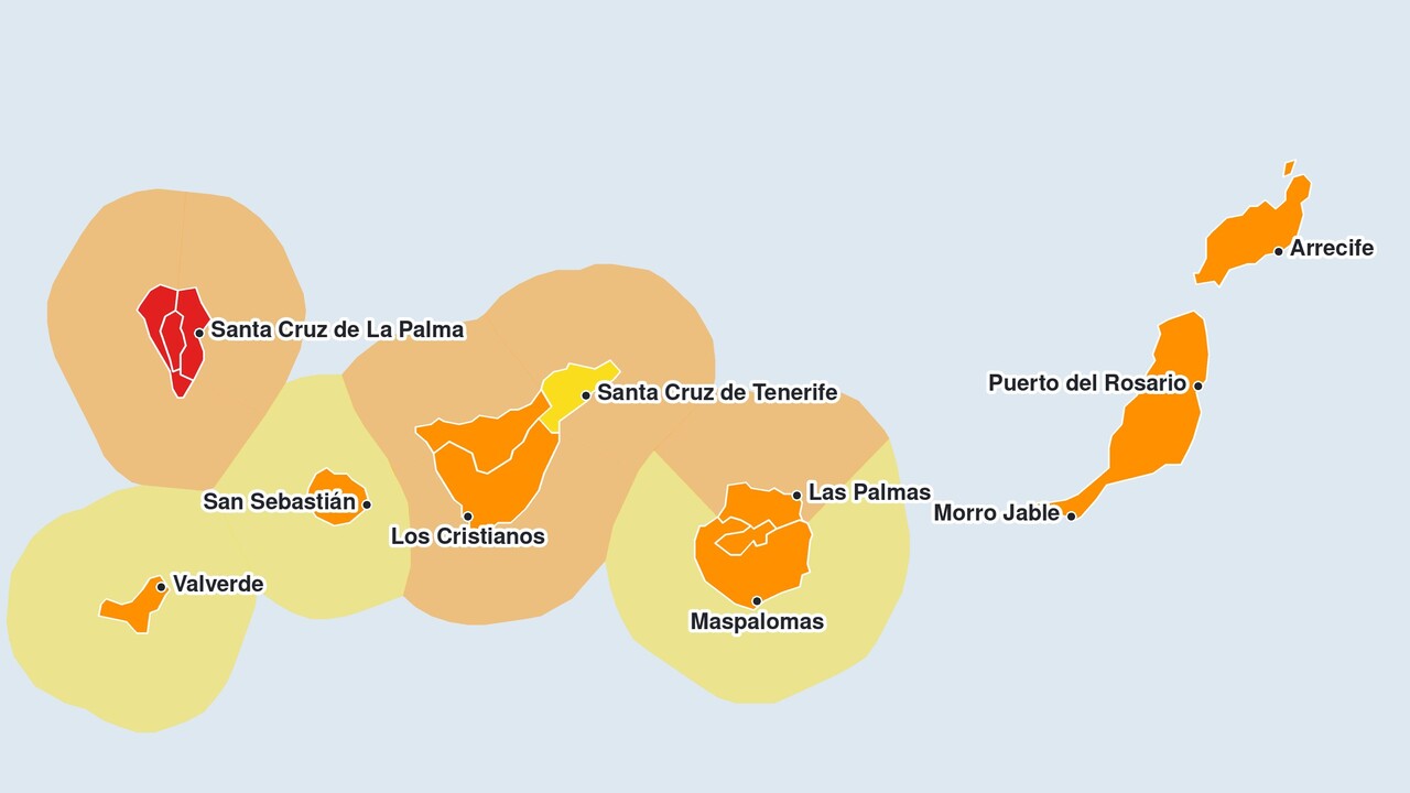
The Spanish Meteorological Agency AEMET has now also issued an Orange warning for gusts of wind on Lanzarote and Fuerteventura. The orange warning is in force on Wednesday from 6.00 am to 5.59 pm, meaning the weather situation is changing on the eastern islands. The AEMET expects gusts of up to 90 kilometres per hour there. This means that on Wednesday, every island in the Canary Islands will be under at least an orange warning.
For the two eastern islands, the Met Office estimates the probability of occurrence at between 10 and 40 per cent; for all other islands, it is between 40 and 70 per cent. The wind is blowing from the south-west and will affect the whole of Lanzarote and Fuerteventura, but will be strongest on the northern and north-western slopes. From 3.00 pm to 9.59 pm, a yellow warning for rain will also be in force, with up to 15 millimetres expected in one hour. Along the coasts of both islands, a yellow warning for rough seas will be in force from 7.00 am: on Fuerteventura until 12.59 pm, and on Lanzarote until 3.59 pm.
The most severe warning concerns La Palma. Following the upgrade of the wind warning for La Palma to red, the highest alert level will be in force there from 3.00 am to 11.59 am, with gusts of up to 130 kilometres per hour. The south-westerly wind will be strongest on the mountain peaks, the north-western slopes and the eastern and south-eastern flanks. From 12.00 to 15.59, a yellow warning will then be in force, with gusts of up to 70 kilometres per hour. Until 1.59 pm, the AEMET is also issuing an orange warning for rain: up to 30 millimetres in one hour and up to 60 millimetres in twelve hours. An orange warning for rough seas is in force on the east and west coasts until 9.59 am.
Wind warning on Tenerife: gusts of over 130 kilometres per hour
On Tenerife, an orange alert has been in force since Tuesday at 9.00 pm for the north as well as for the east, south and west, and will remain in place until Wednesday at 1.59 pm. The AEMET is forecasting gusts of up to 110 and up to 120 kilometres per hour. The south-westerly wind is affecting mainly the higher ground and the coasts at the western tip; on the mountain peaks, it may locally exceed 130 kilometres per hour. The south-eastern slopes are also particularly affected. From 2.00 pm to 5.59 pm, a yellow warning will be in force, with gusts of up to 70 kilometres per hour.
In the greater Santa Cruz area and La Laguna, a yellow warning is in place until 17.59 due to winds with gusts of up to 70 kilometres per hour, particularly at medium and higher altitudes. A yellow warning for rain of up to 20 millimetres in an hour is in force in the north from 6.00 am to 3.59 pm, in the east, south and west from 6.00 am to 5.59 pm, and in the Santa Cruz and La Laguna areas from 12.00 pm to 5.59 pm. Along the coasts, the AEMET has issued an orange warning for rough seas due to winds from the west to south-west of 50 to 74 kilometres per hour, equivalent to 7 to 8 on the Beaufort scale. This warning was in force in the north until 6.59 am; in the Santa Cruz and La Laguna areas, as well as in the east, south and west, it remains in force until 12.59 pm. After that, a yellow warning will be in force along the coasts, and in the east, south and west until 8.59 pm.
Wind warning for Gran Canaria, La Gomera and El Hierro: Orange
Following the upgrade of the wind warning for Gran Canaria, an orange warning is in force across the whole island from 00:00 to 17:59. The AEMET is forecasting gusts of up to 90 and up to 100 kilometres per hour. The central areas and large sections of the coastline in the north-west and south-west are particularly affected; at higher altitudes, wind speeds may exceed 110 kilometres per hour. From 9.00 am to 7.59 pm, a yellow warning is also in place due to rain of up to 15 millimetres in an hour. On the north coast, an orange warning for rough seas is in force until 12.59 pm, whilst a yellow warning applies to the remaining coastlines until 3.59 pm.
On El Hierro and La Gomera, an orange alert has been in place since Tuesday at 9.00 pm until Wednesday at 5.59 pm, with gusts of up to 100 kilometres per hour. On El Hierro, the south-westerly wind is affecting mainly the higher ground and the coasts at the eastern and western ends of the island. On La Gomera, it is affecting large parts of the mid-altitude areas and the peaks, as well as the coasts in the north-north-west and south-south-east. Both islands are also under a yellow warning from 6.00 am to 3.59 pm due to rain of up to 20 millimetres in an hour.
If it rains or there are thunderstorms in the mountains of La Palma and Gran Canaria, water can collect in the barrancos and rush down as a torrential stream towards the coast. You should therefore take particular care in and around the ravines.
For exactly how the weather is developing, see our always up-to-date weather forecast for the Canary Islands. Below you can go straight to…








Comments (0)
No comments on this article yet.