

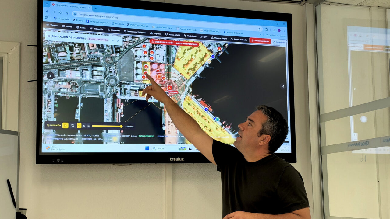
With the help of AI, Puertos de Las Palmas has created the first tool for managing, in real time, any incident that may affect its five facilities, using a visualisation tool that can predict, within 40 seconds, the radius of impact and the time it will take for an emergency to affect its businesses and the local population, thereby ensuring a more efficient response.
This platform, developed by Fermín Ramírez, Head of Security and Safety at the Las Palmas Port Authority, and his partner, who is studying for a master’s degree in AI, aims to provide the ports of Las Palmas de Gran Canaria, Arinaga, Salinetas, Puerto del Rosario and Arrecife with a tool to streamline the procedures to be followed in the event of the 150 potential incidents outlined in the internal emergency plans for these facilities, where 92 tanks containing different types of fuel are in operation.
Ramírez plans to present this management tool to the other port authorities, where nothing similar currently exists, and it will be ready for reliable use in Las Palmas from mid-December, as he explained on Thursday.
Ports of Las Palmas: AI simulates various emergencies
This platform’s visualisation tool, which has been fed with official data from the State Meteorological Agency and the National Geographic Institute, as well as other data relating to the location and characteristics of the various facilities, terminals and companies at the ports of Las Palmas and their maximum capacity, enables users to simulate how a fire, an explosion, a volcanic eruption, an earthquake or a tsunami might unfold.
He also pointed out that it indicates how quickly it could affect port operations and, through a knock-on effect, the rest of the population, something which is of vital importance, particularly for the fire service, he emphasised.
Depending on factors such as wind direction or speed, it will be possible to determine in real time the extent of a toxic cloud, which will facilitate the coordination of an evacuation or a shelter-in-place order, as determined on a case-by-case basis. This information will first be communicated via WhatsApp, followed by a confirmatory telephone call to the safety officers at each company, as well as to 112, Civil Protection and the Harbour Master’s Office, he said.
The tool not only pinpoints the location of the emergency, but also informs the agencies involved in resolving it of how many people may be affected and the type of goods stored or used in the area, based on the UN number, a four-digit international code that identifies dangerous substances, materials and objects during transport (such as explosives, flammable liquids, toxic substances or gases), so that the potential risk to human health can be quickly assessed.
All this information makes it possible to anticipate potential scenarios and identify the various types of risks that may be encountered. It also facilitates the geolocation of the various hydrants located in the ports, so that firefighters know what equipment they need to transport to the scene, depending on the distance of those water outlets from the scene.
Port infrastructure: Tanks and cameras complement risk assessments
Furthermore, the height, diameter and maximum capacity of each fuel tank are specified; the largest tank at the port of La Luz is the Orix tank, which is 24 metres high and 40 metres in diameter, and can store up to 30,159 cubic metres of fuel oil and diesel.
This dashboard displays 110 companies registered at the ports of Las Palmas, although there are more, as well as the locations of their 347 cameras, which will be of great assistance to the emergency services in seeing, in real time, what is happening in each of the areas they cover.
Ramírez has highlighted the usefulness of the data provided by the AEMET in determining, for example, tidal conditions and wind patterns, information that makes it possible to quantify, with a margin of error of two minutes, how long it will take for any fuel spill that may occur during an operation to affect a sensitive port area or spread beyond the port.








Comments (0)
No comments on this article yet.