

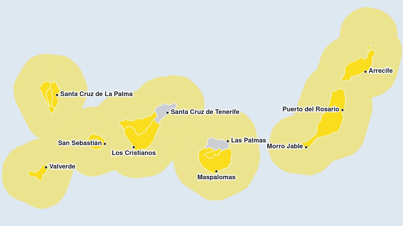
The weather service AEMET has issued a yellow rain warning for several of the Canary Islands. The islands affected are Tenerife, La Palma, La Gomera and El Hierro, where up to 80 millimetres of rain is expected to fall within twelve hours, with up to 20 millimetres in a single hour. The yellow alert is in force from 3.00 pm on Tuesday and ends at 2.59 pm on Wednesday; on Tenerife, it applies to the east, south and west. These same islands are also subject to a separate wind warning, which is discussed below. As with all other warnings, the AEMET estimates the probability of this one occurring at between 40 and 70 per cent.
The authorities expect the heaviest rainfall on the slopes facing south and west. From 6.00 pm on Tuesday, Gran Canaria will be under its own rain warning for the east, south and west of the island. The Met Office considers rainfall of up to 20 millimetres per hour and up to 60 millimetres within twelve hours to be possible there, again mainly in the south and west. This warning will also expire on Wednesday at 2.59 pm.
Also from Tuesday at 3 pm, a yellow warning will be in force due to gusts of wind of up to 70 kilometres per hour on El Hierro, La Palma, La Gomera and Tenerife, including the northern part of the latter. On Gran Canaria, the same alert level comes into effect at 6 pm, affecting the mountainous regions as well as the east, south and west. According to the AEMET, the mountain peaks and the slopes facing south-east and north-west will be particularly affected by the gusts. From midnight onwards, the meteorological office will raise the wind speeds.
Canary Islands: Gusts reach up to 120 kilometres per hour
A wind warning is in place for Wednesday from midnight until 17.59, with gusts of up to 80 kilometres per hour. It applies to El Hierro, La Palma, La Gomera, the whole of Tenerife, and the summit region, east, south and west of Gran Canaria. In high-altitude areas and on the mountain peaks, the AEMET considers winds of over 90 kilometres per hour to be likely in some places. On the peaks of La Palma and Tenerife, it does not rule out localised winds of up to 120 kilometres per hour.
This time, the wind warning on Wednesday extends as far as the eastern islands, as a yellow warning is in place on Fuerteventura and Lanzarote from 9.00 am to 8.59 pm due to gusts of up to 70 kilometres per hour.
Coastal warnings extend from La Palma to Lanzarote
Due to rough seas, warnings will be in force along the coasts on Wednesday at staggered times. First, from midnight until 9.59 pm, the coast of Tenerife in the Santa Cruz and La Laguna areas, as well as in the east, south and west, and the north coast of Gran Canaria, will be affected. The AEMET forecasts south-westerly winds of 50 to 61 kilometres per hour in these areas, corresponding to wind force 7. Off the east and west coasts of La Palma, the warning is in force from 3.00 am to 8.59 pm; in addition to the wind, the meteorological office lists a combined sea state from the west of 4 metres there.
From 9.00 am until 8.59 pm, the coasts of El Hierro and La Gomera, as well as the north coast of Tenerife, will be included. From 12.00 noon until 9.59 pm, the east, south and west of Gran Canaria and the coasts of Fuerteventura and Lanzarote will follow. For all these areas, the AEMET forecasts a south-westerly wind of force 7.
There is also a specific danger in the barrancos on La Palma. Rain and thunderstorms in the mountains can trigger flash floods there, which carve their way through the gorges down to the coast. For this reason, particular caution is advised in and around the barrancos.
For exactly how the weather is developing, see our always up-to-date weather forecast for the Canary Islands. Below you can go straight to…






Comments (0)
No comments on this article yet.