

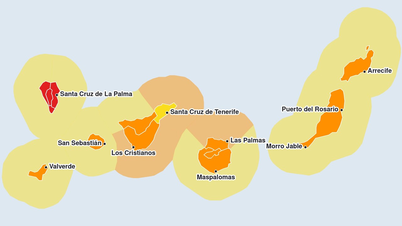
The Spanish Meteorological Agency AEMET has issued a red alert for the whole of La Palma on Wednesday until 11.59 am due to gale-force winds. Since 3 am, the agency has been forecasting south-westerly gusts of up to 130 kilometres per hour, particularly in the summit region, on the north-western slope and on the eastern and south-eastern flanks. The AEMET estimates the probability of these conditions occurring at between 40 and 70 per cent.
Only an orange alert is in force on Tenerife. Nevertheless, the meteorological service considers local gusts of over 130 kilometres per hour possible even there in the higher elevations – figures on a par with the red alert for La Palma. The areas most affected are the higher ground and the coasts in the far west of the island; the wind is also hitting the south-eastern slopes particularly hard. The orange warning for the north, as well as for the east, south and west, has been in place since Tuesday at 9.00 pm until Wednesday at 1.59 pm. As a guide, the AEMET cites gusts of up to 110 and 120 kilometres per hour respectively.
The weather service had initially issued an orange alert for all the Canary Islands on Wednesday. Only afterwards did it upgrade La Palma to red, as the only island to do so. Even before the red alert came into effect, the station at Roque de los Muchachos recorded the strongest gusts of all AEMET monitoring stations between Tuesday evening and Wednesday morning. From mid-morning onwards, the warning on La Palma shifted from wind to rain.
La Palma: Heavy rain triggers a storm warning
An orange alert for rain is in force across the whole island from 10 am until midnight. The AEMET forecasts up to 30 millimetres in an hour, particularly in Breña Baja, Breña Alta and Santa Cruz de La Palma. For the mountainous regions and the east, the agency forecasts up to 100 millimetres in twelve hours until 5.59 pm, particularly north of the Caldera de Taburiente. From 6.00 pm, the alert level there will be downgraded to yellow, with up to 60 millimetres expected over twelve hours. The weather service expects the same amount in the west from 7.00 am until midnight.
Due to strong winds, a yellow warning remains in force on La Palma following the red warning period from 12.00 to 15.59, with gusts of up to 70 kilometres per hour. Along the coasts of La Palma, El Hierro and La Gomera, the AEMET has issued a warning from 10.00 am to 12.59 pm of rough seas due to westerly to south-westerly winds of 50 to 61 kilometres per hour, wind force seven. Until late on Tuesday night, there was hardly any rainfall on the island despite the rain warning; the highest amount was recorded in El Paso.
Orange alerts are in force across Tenerife and the rest of the Canary Islands
On Tenerife, the orange alert will be followed by a yellow alert from 2.00 pm to 5.59 pm, with gusts of up to 70 kilometres per hour, once again mainly on the south-eastern slopes. In the Santa Cruz and La Laguna areas, a yellow alert will be in force from midnight until 5.59 pm; there, the wind will affect the mid-altitude and higher areas. The AEMET has issued an orange warning for rough seas until 12.59 pm along the coasts of Santa Cruz and La Laguna, in the east, south and west, and on the north coast of Gran Canaria. Westerly to south-westerly winds of 50 to 74 kilometres per hour are expected, with wind force seven to eight. In the afternoon, a yellow warning will be in force along these coasts, and on the north coast of Tenerife from 10.00 to 15.59.
From 10.00 am to 5.59 pm, El Hierro, La Gomera, Gran Canaria, Fuerteventura and Lanzarote are on orange alert due to a storm. For El Hierro, La Gomera and Gran Canaria, the Met Office is forecasting gusts of up to 100 kilometres per hour; for Gran Canaria, Fuerteventura and Lanzarote, gusts of up to 90 kilometres per hour, with probabilities of 10 to 40 per cent and 40 to 70 per cent respectively. On El Hierro, this mainly affects the higher ground and the coasts in the far east and west; on La Gomera, the mid-altitude areas, the peaks and the coasts in the north-north-west and south-south-east. On Gran Canaria, gusts in the peaks may exceed the threshold, and the mid-altitude areas, the north-western coasts and extensive stretches of the south-west coast are also affected. Fuerteventura and Lanzarote will be affected by the wind across the whole island, particularly on the northern and north-western slopes. A yellow warning for rough seas is in force from 10.00 to 17.59 on the coasts of Gran Canaria to the east, south and west, as well as on the coasts of Fuerteventura and Lanzarote.
Canary Islands: Rain warnings are in place in some areas until Thursday
From 10.00 am, a yellow warning will also be in force on all other islands due to rain of up to 15 millimetres in an hour. The warning will end on Thursday at 4.59 am for El Hierro and La Gomera, at 7.59 am for Tenerife, and at 11.59 am for Gran Canaria, Fuerteventura and Lanzarote. Thunderstorms cannot be ruled out by the AEMET, particularly in the north of Tenerife and on the eastern islands.
Rain and thunderstorms in the higher elevations of La Palma and Gran Canaria can trigger flash floods. The water then rushes through the barrancos all the way to the coast, which is why particular caution is required in the ravines and along their edges.
For exactly how the weather is developing, see our always up-to-date weather forecast for the Canary Islands. Below you can go straight to…





Comments (0)
No comments on this article yet.